Introduction
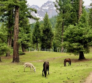
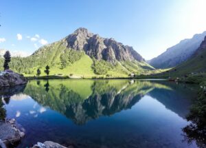
A challenging but rewarding Sierra Nevada trek, the Rae Lakes Loop is famous for its stunning alpine scenery. The experience is improved by favorable weather, such as a clear blue sky. Due to the popularity of the loop, backpackers who desire to enjoy the trail and its stunning views to the fullest need to prepare and plan. The 42+-mile Rae Lakes Circle Trail begins at Road’s End in Kings Canyon National Park. Three major access points to the Rae Lakes Loop Trail are Bubbs Creek Trail, Woods Creek Trail, and Kearsarge Trail. Mission Peak via Hidden Valley Trail is another top beauty to visit with kids and family on vacation.

Rae Lakes Loop Permit
Wilderness permits for the Rae Lakes Loop are $15 per trip and $5 per person during quota season. Permits are bought on Recreation.gov, where you pay the fees upfront. Be aware that permit reservations are non-transferable and that you will need a photo ID. Reservation and walk-up permit fees are equal.
Rae Lakes Loop Counter-Clockwise

Hiking the Rae Lakes Loop counterclockwise starts with a steeper approach compared to hiking clockwise. The hike takes you through the timberline and features wildflowers. The counterclockwise direction may be more challenging to begin with.
Rae Lakes Loop Map
Rae Lakes Loop Campsites

Camping at Rae Lakes Loop is subject to certain rules. Camps must be 100 feet distant from water sources and trails. Camping in Lower Paradise Valley is limited to campsites and restricted to two nights. Dragon Lake has wonderful views for those who prefer solitude, and the southeast side provides wonderful tent views.
Rae Lakes Loop Itinerary

The Rae Lakes Loop is feasible in a 4-night/5-day schedule, beginning at Roads End Ranger Station and proceeding to Upper Paradise Valley on the initial day. The alternative is a 3-day schedule in September, although campsite suggestions and guidance are subject to the hiker’s preference. The loop consists of trails, and preparation for the required permits and campsite reservations is necessary.
Rae Lakes Loop Entrance Point

The Rae Lakes Loop is entered at three major trailheads: Bubbs Creek Trail, Woods Creek Trail, and Kearsarge Pass Trail. The trailhead to use is up to the hiker’s choice, depending on the orientation of the loop and the preference of the hiker. Roads End Trailhead is an alternative, which is accessed via a scenic drive down Kings Canyon. Don’t forget to bring bear canisters and wilderness permits for the loop. Tokopah Falls is another top spot to visit and have an adventure with kids and family.
Rae Lake Loop Trail

The Rae Lakes Loop Trail at Cedar Grove, California, is a strenuous 39.1- to 41.4-mile loop, usually done in 3-5 days. The trail starts at 5,035 feet and rises to 11,978 feet at Glen Pass with an elevation gain of 7,670 feet. It’s a difficult hike, so caution and appropriate experience are advised. Hiking time is usually about 19 hours.
Rae Lakes Loop Weather

Snow cover, especially on passes like Glen Pass, can impact access, not passing until around mid-June, depending on the year. The trail is challenging, especially when traveling late spring or early summer, due to possible snow. Summer is hot and humid for hiking.
Backpacking Rae Lakes Loop

The Rae Lakes Loop is a backcountry trail within Sequoia and Kings Canyon National Parks. The about 39–42-mile hike typically takes three or four days for backpackers. The loop begins at the Roads End Trailhead. Visitors can hike the trail either clockwise or counterclockwise.
Rae Lakes Loop Photos

Rae Lakes Loop Reviews

One of the most famous backpacking trails with stunning vistas is the Rae Lakes Loop. It is usually taken over several days, is a 40-mile loop, and is suitable for moderately experienced backpackers. The total amount of elevation gain, since it can be bunched up in the first few days, in the event it is done counterclockwise. Reviews typically highlight how stunning the experience is. To some, the highlight of the hike is that there is less wildlife and barely any bugs.
Rae Lakes Loop Best Time to Visit

The optimum time of year to do the Rae Lakes Loop is likely July through September, when the weather is nice. You can’t bring your dogs along; they are not permitted on this trail. The road to this section of the park is shut in the winter, so this is a pleasant summer hike. Millerton Lake California is another top place to enjoy blue and chilly water with friends.
Rae Lakes Loop Conditions
Conditions on the Rae Lake Loop vary by location and elevation. In early June, the north side of Glen Pass was deeply snowed in, with the descent difficult without traction. The south side was patchy with snow. The Junction Meadow trail was snow-free. Higher elevations will still have a great deal of snow, so a July hike would be better for less hindrance. Prepare for snow, especially on north slopes.
Rae Lakes Loop Campsites
Rae Lakes camping entails camping in campsites, particularly in places like Lower Paradise Valley. Campers need to choose sites at least 100 feet away from waterways and trails to avoid damaging the environment. There are certain campsites with scenery, such as the southeast side to see the stars, or Dragon Lake to be alone. Sequoia & Kings Canyon National Parks is one of the largest parks in the United States.
Rae Lakes Loop via Kearsarge Pass

The Rae Loop, reached via Kearsarge Pass, is a demanding, California Sierra east backpacking trip. The Independence out-and-back trail is about 24.5 miles and usually takes about 13 hours and 47 minutes to finish. It is a 54-mile, multi-day trip. However, Permits are needed.
Rae Lakes Loop Elevation Gain
The Rae Lake Loop ascends approximately 8,000 to 9,200 feet, although some estimates are more than 11,000 feet. In addition, the difficulty of the trail is generally described as difficult to challenging, and the elevation gain in a distance of approximately 40 to 45 miles.
Rae Lakes Loop Direction
There are three means of doing this trail: from Kearsarge Pass in the Inyo Forest off Hwy 395, counterclockwise from Bubbs Creek Trail (Road’s End in Kings Canyon National Park), or clockwise from Woods Creek Trail (Road’s End in Kings Canyon National Park). Airtopia Adventure Park is another luxurious place to enjoy with kids and family for fun and enjoyment.
Conclusion
For beginners and experienced backpackers, the Rae Lake Trail is a challenging but worthwhile backpacking trail. With world-class scenery, the 42-mile loop, starting and ending at the Roads End Permit Station, takes most 5–6 days to finish. It’s a great trail to use to get your backpacking legs. Although it can be brutal at times, scenery as good as this pays off, and numerous backpackers state that they would have no problem doing it again. No doubt, it is one of my top three backpacking trips.