Neelum Valley Kashmir
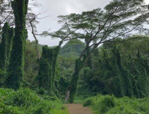
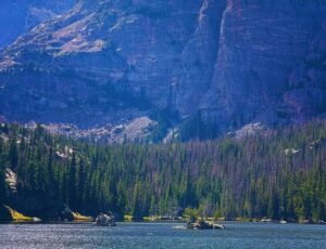
Neelum Valley stretches for approximately 200 kilometres through Azad Kashmir, running parallel to the Kaghan Valley on the other side of the mountain range. The Neelum River flows through the entire length of the valley, forming the natural border with Indian-administered Kashmir along much of its course. The river gives the valley its name and its character. The water is cold, fast, and so blue-green it looks almost artificial. The forest on both banks is dense with pine and cedar, and the mountains above the tree line carry snow for much of the year. The valley runs from Muzaffarabad in the south to Taobat in the north, passing through a series of villages and towns, each with its own character. Keran sits where the valley opens up, and the Indian-administered village of the same name faces it across the river. Kel is the last major town before the road deteriorates seriously. Arrang Kel sits above Kel on a plateau accessible by chairlift or a steep hike. Taobat is the final settlement, 200 kilometres from Muzaffarabad, where the Neelum River crosses into Pakistani territory.
Quick Facts
| Detail | Info |
| Location | Azad Kashmir, Pakistan |
| River | Neelum River (Kishanganga) |
| Length | 200 km from Muzaffarabad to Taobat |
| Altitude Range | 700m to 4,000m+ |
| Distance from Muzaffarabad | Valley starts ~43 km from city |
| Distance from Islamabad | ~160 km — 4 to 5 hours |
| Distance from Lahore | ~723 km — 13 to 14 hours |
| Best Season | April to October |
| Road to Kel | 149 km from Muzaffarabad |
| Highest Point | Ratti Gali Lake at 3,700 metres |
History of Neelum Valley
The Neelum Valley has been settled for centuries, with communities along the river living primarily from agriculture, forestry, and fishing. The valley falls within the broader Kashmir region, and its cultural character reflects the Kashmiri heritage of its people, including language, architecture, food, and the crafts that the region is known for. The partition of India in 1947 divided Kashmir and placed the Neelum Valley within Azad Kashmir under Pakistani administration. The Line of Control, established after the 1948 war and later formalised, runs along the Neelum River through much of the upper valley, which is why visitors travelling toward Kel and Taobat are essentially travelling alongside the border for long stretches of road. The Neelum Valley hydroelectric project, constructed in the 2000s, significantly improved infrastructure in the valley and brought proper road access to areas that were previously very difficult to reach. The project also drew more attention to the valley as a tourist destination, a trend that has grown steadily since then. It is one of the best places to visit in Kashmir.

Places to Visit in Neelum Valley
Ratti Gali Lake
Ratti Gali Lake sits at 3,700 metres above sea level and is one of the highest accessible alpine lakes in Azad Kashmir. The lake is fed by glacial melt and surrounded by peaks that carry snow well into summer. The water reflects the surrounding mountains with a clarity that makes the whole scene look like a slightly exaggerated postcard, except it has not been. The lake is accessible from Dowarian, which serves as the base for the trek upward. The trek from Dowarian to Ratti Gali Lake takes around 4 to 5 hours each way and involves significant elevation gain. The trail passes through forest, then meadow, then open rocky terrain as the altitude increases. Horses are available for hire at Dowarian for those who prefer not to hike the full route. The lake area has basic camping facilities, and staying overnight to watch the sunrise over the surrounding peaks is one of the better experiences the valley offers.
Kel Neelum Valley
Kel sits at approximately 2,097 metres above sea level and is the main hub for the upper Neelum Valley. The town is 149 kilometres from Muzaffarabad along the valley road and serves as a base for visiting Arrang Kel, exploring the upper valley, and accessing trekking routes leading to higher elevations. The surrounding mountains close in around Kel in a way that makes the valley feel particularly contained and dramatic. Kel is accessible by road from Keran, but the last section involves steeper climbs and rougher terrain, and a 4×4 vehicle is recommended, particularly during and after monsoon season when the road surface deteriorates. The town has a small bazaar, several basic hotels and guest houses, and local guides available for the surrounding trekking routes.
Arrang Kel

Arrang Kel is a plateau settlement above Kel, accessible by chairlift or a hike of approximately 2 hours from the valley floor. The chairlift is the more popular option and gives aerial views of the Neelum River valley below as it climbs. Arrang Kel itself sits on a wide flat area with views across to the Indian-administered Kashmir peaks on the other side. The combination of the plateau setting, the distant mountain views, and the forest surrounding the clearing makes it one of the most photographed spots in the entire valley.
Keran Neelum Valley
Keran sits 93 kilometres from Muzaffarabad on the banks of the Neelum River. It is directly across the water from the Indian-administered village of Keran, and the Line of Control runs through the river between the two settlements. The visual impact of seeing the two villages facing each other across a narrow river is something most visitors find unexpectedly affecting. The situation is peaceful day to day, and Keran is a popular stopping point on the valley road. The town has better facilities than the upper valley settlements, including proper hotels, restaurants, and a wider range of accommodation options. Many visitors use Keran as a base and make day trips further up the valley toward Kel and beyond.
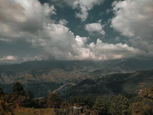
Upper Neelum Valley
Upper Neelum Valley refers to the stretch of the valley beyond Keran, becoming progressively more remote and scenically intense as the road climbs higher and the valley narrows. The section from Keran northward toward Kel and then Taobat is widely considered the most dramatic part of the valley. The road runs closer to the river, the forest is denser, the mountains are higher, and the villages are smaller and further apart. Upper Neelum Valley also offers a variety of accommodation options, including basic guest houses and camping areas, though facilities are noticeably more limited than the lower valley. Visitors heading into the upper valley should carry sufficient supplies and check road conditions before departing, as this section is more vulnerable to monsoon damage and seasonal closures.
Taobat

Taobat is the last settlement in the Neelum Valley, sitting approximately 200 kilometres from Muzaffarabad and 39 kilometres beyond Kel. It marks the point where the Neelum River crosses into Pakistani territory from Indian-administered Kashmir. Due to its remote location, Taobat has very limited amenities, and the road to reach it is rough and requires proper 4×4 transport. The remoteness is itself part of the appeal for visitors who want to reach the furthest navigable point in the valley.
Sharda Valley
Sharda Valley is one of the more fertile sections of the Neelum Valley, known for its meadows, fruit orchards, and traditional stone villages. The Sharda Fort sits in this section of the valley and offers a view into the region’s historical past. Sharda also has the ruins of an ancient university, believed to date back over a thousand years, which once served as an important centre of learning in the Kashmir region. The site is not extensively excavated or developed, but the ruins are visible and give the area a layered historical character that most valley towns lack.
Kutton Waterfall
Kutton Waterfall is one of the most accessible and visited waterfalls in the valley. It cascades into a natural pool at its base, and the surrounding forest creates a cool and shaded environment that makes the area pleasant even in summer. The pool at the base is cold but deep enough for swimming, and many visitors take a dip. The waterfall is not far from the main valley road, which is why it sees more visitors than some of the remoter falls further up the valley.
Waterfalls in Neelum Valley
Dhani Waterfall
Dhani Waterfall is approximately 33 kilometres from Muzaffarabad, making it the most accessible significant waterfall in the valley. It is also considered the highest waterfall in the Neelum Valley, and the combination of the cascading height and the surrounding rock and greenery makes it a worthwhile stop even for visitors on a limited schedule.
Shounter Waterfall and Chitta Katha Waterfall
Shounter Waterfall and Chitta Katha Waterfall are both found in the upper reaches of the valley and require more effort to reach than the lower valley waterfalls. Chitta Katha in particular involves a trek, and the reward is a fall in an Alpine setting that feels genuinely remote. Both are better suited to visitors spending multiple days in the valley who have time to explore beyond the main road stops.
Famous Villages of Neelum Valley
The valley contains a series of villages, each with its own character. Keran is the most developed and accessible. Kel is the adventure hub for the upper valley. Sharda has the historical ruins and the fertile landscape. Dowarian is the gateway village for the Ratti Gali Lake trek. Arrang Kel sits on its plateau above the valley floor. Taobat is the final frontier at the valley’s northern end. Exploring the villages rather than just the scenic viewpoints gives a much more complete picture of how people actually live along the Neelum River. Leepa Valley is another top place to visit with families and friends on vacation.
Neelum Valley Weather
| Season | Temperature and Conditions |
| Spring (April to May) | 10 to 22°C — fresh, green, some rain |
| Summer (June to August) | 15 to 28°C — pleasant days, monsoon rain |
| Autumn (September to October) | 8 to 20°C — clear skies, best visibility |
| Winter (November to March) | Below zero at higher elevations, heavy snowfall |
The valley experiences significant weather variation between the lower and upper sections due to the altitude difference. Muzaffarabad and the lower valley are noticeably warmer than Kel and Taobat at any given time of year. Monsoon season from July through August brings heavy rain that can affect road conditions significantly, particularly in the upper valley. Always check the weather forecast and road conditions before heading into the upper sections during this period.
Best Time to Visit Neelum Valley

April to October gives the best overall window. Spring from April to May brings the valley back to life after winter with fresh greenery and clear rivers still full from snowmelt. September and October are among the best months for both weather and crowd levels, with clear skies, comfortable temperatures, and the autumn colours beginning to appear in the forest. Summer, from June to August, is the peak tourist season because of school holidays and the contrast with lowland heat, but monsoon rain during July and August makes road conditions unpredictable, particularly in the upper valley. Winter closes much of the upper valley from November through March due to heavy snowfall. The road to Kel and beyond becomes impassable, and Taobat is essentially cut off. Visitors wanting to experience the valley in the snow can do so in the lower sections around Keran, but should not attempt the upper valley during winter without confirmed road information. Toli Peer is another top destination to visit on vacation.
Neelum Valley Road Conditions
The valley road stretches approximately 149 kilometres from Muzaffarabad to Kel. The first 93 kilometres to Keran are generally well maintained and suitable for standard vehicles. Beyond Keran, the road narrows, the climbs become steeper, and the surface deteriorates. From Kel onward toward Taobat, the road requires a proper 4×4 vehicle and should not be attempted in a standard sedan. The monsoon season from July through August is when road conditions are most unpredictable. Landslides are a genuine risk in the upper valley during heavy rain, and the road can be closed at short notice. Travelling in the upper valley during the monsoon requires checking with locals or recent travellers about current conditions before departing. The road is at its best from September through June before the next monsoon cycle begins.
How to Get to Neelum Valley
From Islamabad
Islamabad to Muzaffarabad is approximately 160 kilometres and takes 4 to 5 hours via Murree and the AJK route. From Muzaffarabad, the valley road begins, and the total distance to Kel is another 149 kilometres, taking 4 to 5 hours depending on stops and road conditions. Most visitors from Islamabad plan for an overnight stop in Muzaffarabad or Keran rather than attempting the full journey in one day.
Distances from Key Cities
| From | Distance and Time |
| Islamabad to Muzaffarabad | ~160 km — 4 to 5 hours |
| Muzaffarabad to Keran | ~93 km — 2.5 to 3 hours |
| Muzaffarabad to Kel | ~149 km — 4 to 5 hours |
| Kel to Taobat | ~39 km — 1.5 to 2 hours |
| Lahore to Neelum Valley | ~723 km — 13 to 14 hours |
| Peshawar to Neelum Valley | ~363 to 486 km — 7 to 10 hours |
| Murree to Kel | ~291 km — 9 to 10 hours |
| Abbottabad to Valley Start | ~67 km — 1.5 to 2 hours |
| Mirpur to Neelum Valley | ~517 km — 12 to 13 hours |
| Neelum Valley to Naran | ~212 km — 7 to 7.5 hours via N-15 |
Neelum Valley Hotels and Accommodation
The accommodation situation in the valley has improved over the past decade, but still varies significantly between the lower and upper sections. Muzaffarabad and Keran have the widest range of proper hotel options. Kel has smaller guest houses and basic lodges. Upper valley settlements offer very basic accommodation, and camping is common for visitors going beyond Kel.
Hotels in Neelum Valley
| Hotel | Notes |
| Midway Lodges Neelum Valley | Budget friendly, reliable for valley stays |
| Pine Park Lodges AJK | Good mid-range option, mountain views |
| The Twin Hills Resort | Comfortable resort standard |
| Mir Continental Hotel Sharda | Located in Sharda Valley section |
Prices in the valley change significantly between the peak summer season and the shoulder months. Booking in advance for July and August is essential as accommodation fills completely during school holidays. For upper valley visits around Kel and Arrang Kel, confirming availability before travelling is important, given the limited number of rooms at each property.
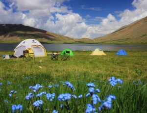
Neelum Valley Camping
Camping is popular throughout the valley and is the primary accommodation format for visitors going to Ratti Gali Lake, the upper valley trekking routes, and areas beyond Kel. The best camping spots are in Kel itself, the Upper Neelum Valley meadows, and around the Sharda Valley section. Camping facilities are generally basic. Visitors should be prepared to be self-sufficient with water, food, and waste disposal. The night skies in the upper valley with minimal light pollution are a reward that makes camping worthwhile beyond just the practicality.
Neelum Valley Map
My Personal Experience at Neelum Valley

The drive from Muzaffarabad into the valley is when you start to understand what people mean when they say this place is different from the rest of AJK. The road follows the Neelum River almost from the start, and the colour of the water is the first thing that stops you. You expect a mountain river to be grey-blue. This one is a deep turquoise that looks like someone has coloured it specifically for the photographs. Keran was where the emotional weight of the valley hit me. Standing on the Pakistani side looking at the Indian-administered village on the opposite bank, separated by maybe 50 metres of river, is one of those travel moments that puts political geography into human terms in a way that reading about it never quite does. The people on both banks look the same, speak the same language, and probably have relatives on the other side. The river between them is both border and memory. The Arrang Kel chairlift was genuinely terrifying in the best possible way.
Essential Tips
- Plan at least 3 nights minimum, one day is not enough to see even half the valley
- A 4×4 vehicle is essential for travel beyond Keran toward Kel and Taobat
- Check road conditions before heading into the upper valley during the monsoon season
- Book hotels in advance for July and August, as the valley fills during peak season
- Carry cash. ATM facilities are not reliable beyond Muzaffarabad
- Pack warm layers regardless of season, upper valley temperatures drop sharply after sunset
- Hire a local guide for the Ratti Gali Lake trek; the trail forks in places, and local knowledge matters
FAQs
Neelum Valley is located in Azad Kashmir, Pakistan. It runs parallel to the Kaghan Valley and stretches approximately 200 kilometres from Muzaffarabad in the south to Taobat in the north, following the Neelum River along the Line of Control with Indian-administered Kashmir.
April to October is the main visiting window. Spring and autumn give the best combination of weather and crowd levels. July and August are the busiest months due to school holidays, but they also bring monsoon rain that can affect upper valley roads. September and October offer excellent weather with fewer crowds.
Islamabad to Muzaffarabad is approximately 160 kilometres, taking 4 to 5 hours. From Muzaffarabad to Kel at the heart of the upper valley is another 149 kilometres and 4 to 5 hours. Most visitors from Islamabad plan for an overnight stop rather than attempting everything in one day.